The story of this region
Natural processes and people with a deep connection to the land have shaped Te Manahuna / the Mackenzie Basin. Steeped with cultural and spiritual significance, the project area has a rich cultural, ecological and social landscape, and is treasured by all New Zealanders.
An evolved landscape
Before the first humans set foot in Te Manahuna / the Mackenzie Basin, the land had already undergone many changes.
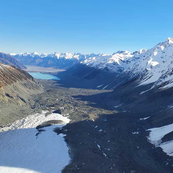
Over millions of years, vast forces raised the mountains, and for thousands more, great glaciers carved paths through these ranges, depositing fertile alluvial sediment along their path.
When the glaciers retreated, they left behind expansive outwash plains, moraines and winding braided rivers that feed into turquoise glacial lakes. Open forest, scrub, tussock and herbfields grew and unique birds, lizards and insects evolved to thrive in the harsh environment.
It was this land that the first people arrived to.
Manawhenua
With permanent settlements on the east coast, whānau from Te Rūnanga o Arowhenua, Te Rūnanga o Moeraki and Te Rūnanga o Waihao would travel to Te Manahuna seasonally, to gather mahika kai, particularly tuna (eels) and weka. Mōkihi (river craft constructed from raupō or reeds) were used to carry resources along the Waitaki River back to the coast.
Some tūpuna (ancestors) would journey further, along aro tawhito (ancient trails) to reach Hāwea and Wānaka, or Te Tai o Poutini (West Coast) in search of pounamu. As a seasonal gathering point, Te Manahuna was an important place of relaxation and enjoyment.
Today, Te Manahuna remains a place of significance. The landscape is woven with memories and traditions, including mahika kai sites, taonga species such as kakī / black stilt, and sites of archaeological importance including pā and urupā. Iwi, hapū and whanau have an immense sense of belonging and connection to the whenua and a desire to enhance their connection to Te Manahuna.
Many of the landmarks in Te Manahuna Aoraki are named after ancestors of the waka atua Āraiteuru.
Watch this video about the legend of Aoraki
European settlers
Sheep rustler James Mackenzie is thought to be the first European to venture over the passes in the 1850s to graze his stolen sheep on the dry tussock landscape. The new settlers who followed took to his name to describe the wide open plains and snowy mountains they saw before them.
Te Manahuna/the Mackenzie Basin drew considerable attention. With Crown-leased farms having already expanded rapidly across the Canterbury plains, the race was on to find new profitable land.
The open and rugged landscape inspired generations of families to set down roots, building a culture of stewardship and a strong sense of community. The pioneer run-holders came to understand the unique challenges of the land. Over time, the production of wool became the economic lifeblood of the area, with tourism operations generating extra income for high-country stations in more recent years.
Fringed by the Southern Alps the high-country stations have become an image of ‘brand New Zealand’. People visit from every corner of Aotearoa and the world and the values of the land are a treasured part of our national identity.
High-country farming families continue to have strong ties to the land, and a connection to place. As stewards of the land for generations they have invested time and resources to protect the iconic landscapes and species from the many weeds and pests that threaten their survival.
Watch this video about the farmers of Te Manahuna Aoraki
Threats
Despite being recognised for its natural beauty, Te Manahuna / the Mackenzie Basin has been modified by many forces. The once forested land has been transformed into tussock grasslands and pasture. Introduced pests and weeds, and hydro-electricity developments have altered the landscape and its natural values.
Braided river habitat, historical nohoanga (campsites), makatea (tracks) and farmland were lost when lake levels were raised for hydro developments. Along with the impact of introduced predators and weeds, these changes have restricted the ability for manawhenua to gather mahika kai.
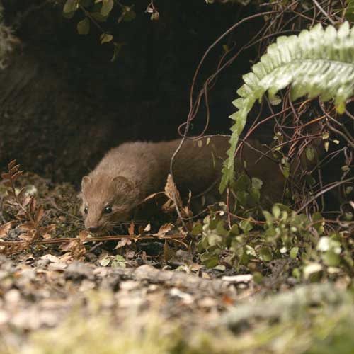
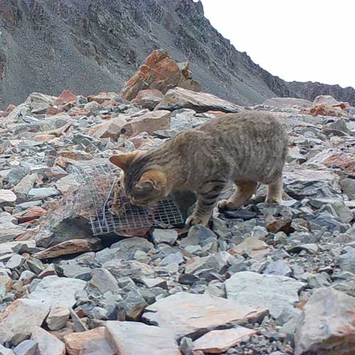
Hedgehogs, stoats and feral cats swarm across the landscape, robbing the nests of braided river birds and killing lizards and invertebrates. In the front country, rabbits chew through native vegetation, while tahr, hares, wallabies and deer browse the alpine slopes.
Weeds flourish in the disturbed riverbed channels, slowly smothering native plants and shading basking habitat for lizards and grasshoppers.
Pest animals and plants also threaten the high-country farm values of Te Manahuna/the Mackenzie Basin, with control of invasive species like wilding pines and rabbits incurring considerable costs each year.
Stoat photo Peter Young, Fight for the Wild
Aoraki Mount Cook National Park
Today, Aoraki Mt Cook is administered by the Department of Conservation. While the approx 70,000 ha national park was only officially gazetted in 1953, reserves to protect the area’s significant vegetation and landscape were established as early as 1887. The park includes New Zealand’s highest peak, Aoraki / Mt Cook (3754m), and longest glaciers.
Sharing a border along the Main Divide with Westland Tai Poutini National Park, it is part of Te Wāhipounamu – South West New Zealand World Heritage area, and internationally recognised as a UNESCO World Heritage site and one of the great natural areas of the world.
There is a long history of tourism in the area, with annual visitors peaking at 1 million in 2019.
The first Hermitage Hotel was built in 1884 at White Horse Hill (the site of the present campground). The original hotel was damaged by flooding from the Mueller Glacier, so a new Hermitage was built in 1912-13 at what we now know as Mount Cook village.
Many of the weed infestations the project is now controlling are garden escapees from some of these early sites.
To Ngāi Tahu, Aoraki represents the most sacred of ancestors. In 1998, a settlement between Ngāi Tahu and the Crown saw the official renaming of the mountain from Mount Cook to Aoraki Mount Cook, to ensure the importance and significance of the mountain’s Māori heritage was not lost.
Photo credits: Simone Smits, Dave Kwant